


Beaulieu 10 mars 2022

rlebasque
User

Length
18.9 km

Max alt
468 m

Uphill gradient
412 m
Km-Effort
24 km

Min alt
246 m

Downhill gradient
410 m
Boucle
Yes
Creation date :
2022-03-10 08:10:26.566
Updated on :
2022-03-10 15:48:41.234
7h37
Difficulty : Very difficult

FREE GPS app for hiking
 SityTrail
IGN / Geographical institutes
SityTrail Plus
The world is yours!
About
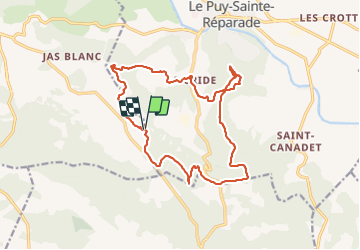
Trail Walking of 18.9 km to be discovered at Provence-Alpes-Côte d'Azur, Bouches-du-Rhône, Le Puy-Sainte-Réparade. This trail is proposed by rlebasque.
Positioning
Country:
France
Region :
Provence-Alpes-Côte d'Azur
Department/Province :
Bouches-du-Rhône
Municipality :
Le Puy-Sainte-Réparade
Location:
Unknown
Start:(Dec)
Start:(UTM)
694075 ; 4834087 (31T) N.
Comments